

DNREC Menu
When monitoring reveals that waterways do not meet Delaware’s water quality standards for their intended uses, as defined in Delaware’s Surface Water Quality Standards, they are added to a list of impaired waterways (Delaware’s 303(d) List). For each impaired waterway, the Federal Clean Water Act (CWA) requires states to develop Total Maximum Daily Loads (TMDLs) or other restoration approaches for the pollutants of concern.
The goals of these approaches are to achieve water quality that allows for unrestricted intended usage, including for drinking, agricultural or industrial supply water, recreational purposes and/or for the health of fish and aquatic life and for people who consume them.
A TMDL sets a limit on the amount of a pollutant that can be discharged into a waterbody while still maintaining water quality standards. When numerous sources of a pollutant exist within a watershed, a TMDL is a useful tool for establishing limits and monitoring requirements for discharges.
When sources of the pollutants of concern (POC) are more diffuse and historic in nature, TMDLs are not effective, by themselves, to meet water quality standards. In those cases, other restoration approaches are now recognized by the Environmental Protection Agency as a way to achieve water quality goals more effectively and efficiently.
These other restoration approaches are referred to as Advance Restoration Plans (ARPs) and are intended to be used in advance of developing a TMDL.
Pollutants in Delaware waters include nutrients such as nitrogen and phosphorus, toxic chemicals such as metals, pesticides, and polychlorinated biphenyls (PCBs), bacteria and even excess sediment.
Sources of the pollutants can be wastewater discharges and surface runoff from industrial and agricultural practices in both urban and rural environments. TMDLs and ARPs are used to aid in the reduction of impairment-driving pollutants like these.
Pollutants can originate from both point sources and nonpoint sources.
Point sources are discrete sources of pollution and include facilities that have a National Pollution Discharge Elimination System (NPDES) permit such as municipal and industrial wastewater treatment plants or urban areas with Municipal Separated Storm Sewer System (MS4) permits.
Nonpoint source pollution originates from many diffuse sources that are harder to pinpoint, including agricultural and urban landscapes, septic systems and runoff from lawns, farms, roads, parking lots, and golf courses.
Setting pollution limits and identifying pollutant sources is just the first step toward improving water quality. Once the pollutant limits are established, efforts must be taken to reduce the pollutant loads from point and nonpoint sources.
The DNREC Watershed Assessment and Management Section works with partners across the state to identify voluntary and regulatory actions that can be taken in impaired watersheds to reduce pollutant loading.

Delaware has been establishing TMDLs for the state’s highest priority impaired waterways since 1998 using data-driven models. Continuous and discrete water quality monitoring data, in addition to permit-required monitoring data, helps DNREC determine whether improvements are occurring.
In 2024, Delaware developed its first watershed-based Advance Restoration Plan (ARP) to identify and address historical sources of toxic chemical pollutant impairments related to fish consumption. This Advance Restoration Plan for The C&D Canal Watershed will serve as a framework for ARPs for pollutants of concern (POCs) in watersheds throughout the state in the future.
The tables below list all of the TMDLs that have been established in Delaware and provides links to technical analysis documents and any resulting regulations.
Each tab includes the watersheds in a major drainage area. Each watershed listed is numbered and shown on the map on this page.
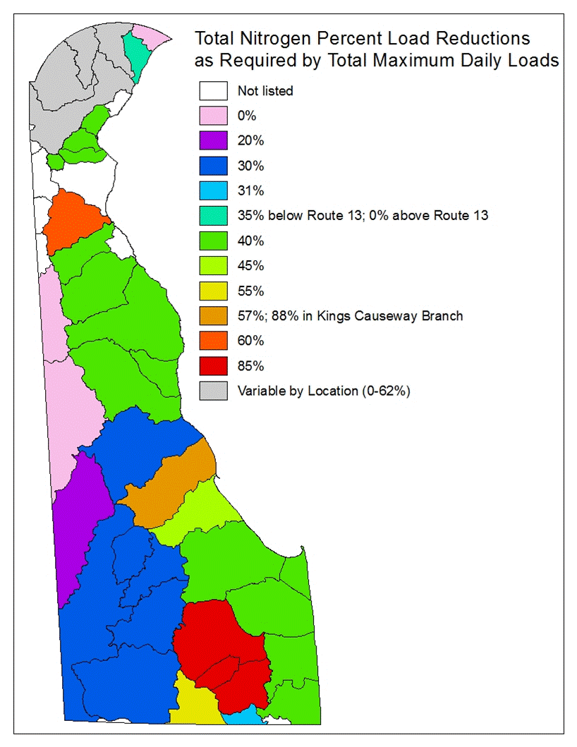
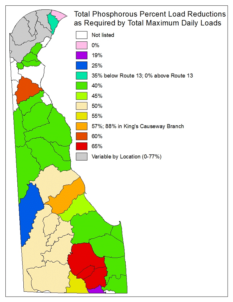
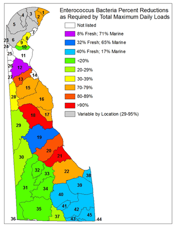
In addition, the maps at the bottom of the page show the percent reductions in nonpoint source nitrogen, phosphorus and bacteria loads that are required by the TMDLs in order to achieve water quality goals.
| Watershed | Developed by | Year | Analysis Documents | Regulations |
|---|---|---|---|---|
| Naamans Creek (1) | DNREC | 2005 | Nutrients and Bacteria | Nutrients and Bacteria |
| Shellpot Creek (2) | DNREC | 2005 | Nutrients and Bacteria | Nutrients and Bacteria |
| Brandywine Creek (3), Red Clay Creek (4), White Clay Creek (5), and Christina River (6) | EPA | Revised 2006 2006 Revised 2006 |
High-Flow Nutrients High-Flow Bacteria Low-Flow Nutrients |
|
| Red Clay Creek (4) | DNREC | 1999, Amended 2009 | Zinc | Zinc |
| White Clay Creek (5) | DNREC | 1999 | Zinc | Zinc |
| Watershed | Developed by | Year | Analysis Documents | Regulations |
|---|---|---|---|---|
| Army Creek (8) | DNREC | 2006 | Nutrients and Bacteria | Nutrients and Bacteria |
| Red Lion Creek (9) | DNREC | 2006 | Nutrients and Bacteria | Nutrients and Bacteria |
| Dragon Run Creek (10) | DNREC | 2006 | Nutrients and Bacteria | Nutrients and Bacteria |
| C&D Canal East and Lums Pond (11) | DNREC | 2012 | Nutrients | Nutrients |
| Appoquinimink River (12) | EPA DNREC |
2003 2006 |
Nutrients Bacteria |
Bacteria |
| Blackbird Creek (13) | DNREC | 2006 | Nutrients and Bacteria | Nutrients and Bacteria |
| Smyrna River (15) | DNREC | 2006 | Nutrients and Bacteria | Nutrients and Bacteria |
| Leipsic River (16) | DNREC | 2006 | Nutrients and Bacteria | Nutrients and Bacteria |
| Little Creek (17) | DNREC | 2006 | Nutrients and Bacteria | Nutrients and Bacteria |
| St. Jones River (18) | DNREC | 2006 | Nutrients and Bacteria | Nutrients and Bacteria |
| Murderkill River (19) | DNREC DNREC |
2014 Amended 2006 |
Nutrients Bacteria |
Nutrients Bacteria |
| Mispillion River (20) | DNREC | 2006 | Nutrients and Bacteria | Nutrients and Bacteria |
| Cedar Creek (21) | DNREC | 2006 | Nutrients and Bacteria | Nutrients and Bacteria |
| Broadkill River (22) | DNREC | 2006 | Nutrients and Bacteria | Nutrients and Bacteria |
| Delaware Estuary Zones 2-5 | EPA | 2003 | PCBs | |
| Delaware Estuary Zone 6 | EPA | 2006 | PCBs | |
| Watershed | Developed by | Year | Analysis Documents | Regulations |
|---|---|---|---|---|
| Chester River (28), Choptank River (29), Marshyhope Creek (30), Nanticoke River (31), Gum Branch (32), Gravelly Branch (33), Deep Creek (34), Broad Creek (35), and Pocomoke River (37) | DNREC | 2006 | Bacteria | Bacteria |
| Chester River (28) | DNREC | 2005 | Nutrients | Nutrients |
| Choptank River (29) | DNREC | 2005 | Nutrients | Nutrients |
| Marshyhope Creek (30) | DNREC | 2005 | Nutrients | Nutrients |
| Nanticoke River (31) and Broad Creek (35) | DNREC | 1998 | Nutrients in the mainstem of the Nanticoke River and Broad Creek | |
| Gum Branch (32), Gravelly Branch (33) and Deep Creek (34) | DNREC | 2000 | Nutrients in the tributaries and ponds of the Nanticoke River and Broad Creek | |
| Pocomoke River (37) | DNREC | 2005 | Nutrients | Nutrients |
| Watershed | Developed by | Year | Analysis Documents | Regulations |
|---|---|---|---|---|
| Lewes-Rehoboth Canal (38), Rehoboth Bay (39), Indian River (40), Iron Branch (41), Indian River Bay (42), Buntings Branch (43), Assawoman Bay (44), and Little Assawoman Bay (45) | DNREC | 2006 | Bacteria | Bacteria |
| Lewes-Rehoboth Canal (38), Rehoboth Bay (39), Indian River (40), Iron Branch (41), and Indian River Bay (42) | DNREC | 1998 | Nutrients | Nutrients |
| Little Assawoman Bay (45) | DNREC | 2005 | Nutrients | Nutrients |
| Indian River (40) | EPA | 2004 | Temperature | |
| Buntings Branch (43) | DNREC | 2004 | Nutrients | |
Delaware's Governor
State Agencies
Elected Officials
General Assembly
Delaware Courts
State Employees
Cities & Towns
Delaware State Code
State Regulations
Business First Steps
Phone Directory
Locations Directory
Public Meetings
Voting & Elections
Transparency
Health Insurance
Tax Center
Personal Income Tax
Privacy Policy
Weather & Travel
Contact Us
Corporations
Franchise Tax
Gross Receipts Tax
Withholding Tax
Delaware Topics
Help Center
Mobile Apps
E-mail / Text Alerts
Social Media

Built by the Government Information Center
©MMXXVI Delaware.gov