

DNREC Menu
DNREC’s Coastal Programs is spearheading the development of a Delaware Ocean and Bay Plan to identify responsible management and stewardship practices that are applicable to the use and conservation of marine resources off Delaware’s coast.
The Delaware Ocean and Bay Plan will provide a comprehensive, easy to use resource for decision makers and stakeholders. Developing the plan will include public input and review by stakeholders, residents and the public at large.
The demand for space in the waters off Delaware’s coast is escalating faster than ever before. Existing uses, such as commercial shipping, and newly emerging uses, such as underwater transmission cables, are expanding.
As the marine resources and activities off our coast are forced to adapt to changing sea levels, warming waters and acidification, it’s important to ensure balance between ocean and bay uses and conservation of marine resources.

The preliminary goals of the Ocean and Bay planning process include:
Using the plan to better understand and manage resources and uses occurring off Delaware’s coast and in the Delaware Bay.
Protecting marine resources, ecological functions, and ocean/bay uses that provide long-term economic and social benefits for all Delawareans while recognizing and considering how current and emerging uses may impact the state.
Inspiring pride and stewardship in Delaware’s ocean and bay through education and knowledge-sharing.
Highlighting the ways the public can get involved in acting as stewards of the ocean and bay.
The Delaware Ocean and Bay planning effort will include three core components: an Ocean and Bay Activity Guide, Ocean and Bay Plan, and Ocean and Bay Planning Tool.
The Activity Guide will serve as an inventory of marine activities and resource taxa groups, characterized both spatially and temporally.
The Ocean and Bay Plan will serve as a reference document for existing and potential new ocean and bay users. It will:
The Ocean and Bay Planning Tool will serve as a visual platform to explore the activities and resources off Delaware’s coast along with best practices for minimizing conflict.
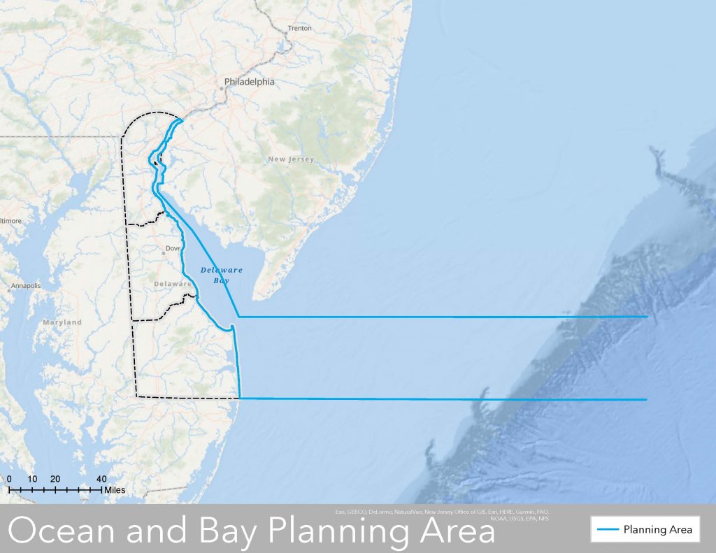
The Planning Area includes Delaware’s jurisdictional marine waters in the Delaware Bay and Atlantic ocean.
To better understand the interactions between uses and resources occurring offshore, this plan will consider activities that extends eastward of the Delaware Atlantic coast, past the continental shelf and slope.
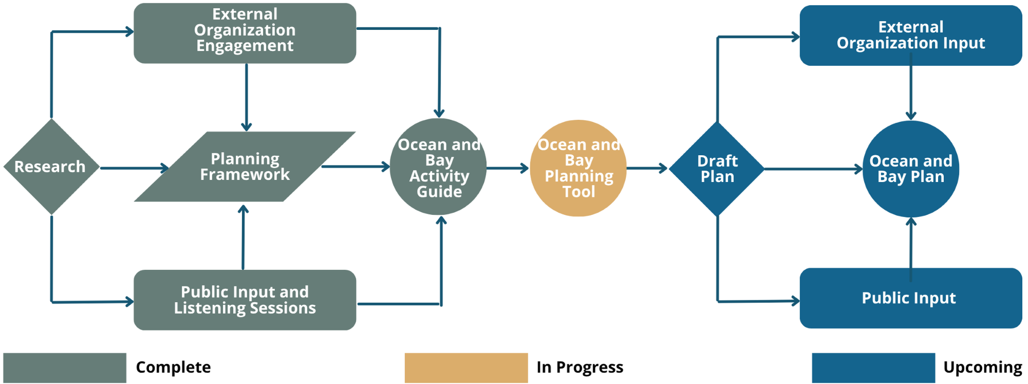
The Ocean and Bay Plan development process began with extensive research, to provide a detailed understanding of Delaware’s coastal and offshore environments.
The research began with an analysis of other state ocean plans and DNREC’s regulatory authorities to determine an approach suitable for Delaware. The result was a detailed inventory of the Department’s authorities to regulate and address ocean resources and uses, in both state and federal waters.
Key findings from other states highlighted the importance of public participation and challenges in data availability.
Throughout late 2022 and early 2023, DNREC’s Coastal Programs conducted extensive stakeholder engagement through interviews with 55 subject matter experts, resource managers and governmental organizations to ensure the water-dependent activities that are important to those organizations and experts were heard and considered for inclusion in the ocean and bay planning effort.
Through listening sessions and a coinciding public comment period held in Summer 2023, DNREC received input from 50 individuals sharing what makes the ocean and Delaware Bay special to them. The goals of this public engagement included understanding the marine resources and uses that are important to Delawareans, what they’d like to learn more about, what information they need to provide input or ask questions about potential actions occurring in the ocean or Delaware Bay and how they currently use the ocean and Bay.
The values and priorities identified by external stakeholders and the public fit into three main planning themes (Blue Economy, Blue Environment and Blue Foundation) and seven buckets (Recreation and Tourism, Maritime, Offshore Energy, Marine Resource Conservation, Anthropogenic Impacts, Submarine Infrastructure and Marine Minerals) that were shaped based on the responses to be inclusive of all priorities.
The resulting analysis, aligning with stakeholder interests, set the stage for the foundational planning framework of the ocean and bay planning effort.
The plan development process included three public listening sessions in the summer of 2023 — June 28, in New Castle, July 12, in Lewes, and July 23, in Dover.
The listening sessions held in each county provided attendees with an overview of why the ocean and bay are important and information on the activities and resources off the coast of Delaware through an introductory presentation and graphic posters in English, Haitian Creole and Spanish.
Participants in the listening sessions identified topics of importance to help guide the planning process:
Learn more about the Public Interests and Priorities identified for the Ocean and Bay Plan.
Marine activities and resource groups that occur off Delaware’s coast were characterized to describe their current uses, with both spatial and temporal context.
This research effort, conducted by University of Delaware’s Dr. James Rising, provided geospatial data and insights to inform development of the Ocean and Bay Plan, culminating in a report titled “Ocean and Bay Plan Information Gaps Project: Baseline characterization of uses and resources.”
Standardized snapshots of information about each marine activity and resource group can be accessed in the Ocean and Bay Activity Guide series.
Under Development
An identified need and additional element of the ocean and bay planning effort will include a GIS-based Ocean and Bay Planning Tool that will offer a dynamic visualization platform for both current and prospective users of ocean and bay areas.
Through intuitive navigation and interactive features, users will have the ability to navigate the map and toggle data layers on and off. Users can then select an input use or resource, draw a polygon in desired location, which will query other uses and resources in the area, describe their compatibility level and generate a report on how the selected use or resource may conflict with the other identified uses and resources in the area and list suggested practices for conflict resolution.
Join our mailing list to keep up with progress in development of Delaware’s Ocean and Bay Plan.
Related Topics: atlantic ocean, bay, climate coastal energy, coastal management, coastal programs, delaware bay, marine resources, ocean, planning
Delaware's Governor
State Agencies
Elected Officials
General Assembly
Delaware Courts
State Employees
Cities & Towns
Delaware State Code
State Regulations
Business First Steps
Phone Directory
Locations Directory
Public Meetings
Voting & Elections
Transparency
Health Insurance
Tax Center
Personal Income Tax
Privacy Policy
Weather & Travel
Contact Us
Corporations
Franchise Tax
Gross Receipts Tax
Withholding Tax
Delaware Topics
Help Center
Mobile Apps
E-mail / Text Alerts
Social Media

Built by the Government Information Center
©MMXXVI Delaware.gov