

DNREC Menu
Monitoring Delaware’s species of greatest conservation need (SGCN), their habitats, and the effectiveness of the conservation actions identified in the Delaware Wildlife Action Plan will provide information for Delaware Department of Natural Resources and Environmental Control (DNREC), Division of Fish and Wildlife (DFW) and its partners to measure success of the Delaware Wildlife Action Plan (DEWAP) (Element 5). Monitoring will help determine the effectiveness of conservation actions, ensuring the most efficient use of limited staffing and funds, and will reduce or eliminate threats facing the state’s fish and wildlife resources. As conditions change (e.g., land use patterns, climate change, global or national population trends, new data and information), adaptive management and implementation of the conservation actions identified in Conservation Actions will allow DNREC DFW to respond appropriately. Adaptive management has received ample attention in the conservation community as an effective method for long-term conservation.
The DEWAP is strategic in nature and presents a monitoring and adaptive management framework that will be used to assess the status of SGCN and habitats as well as monitor the effectiveness of conservation actions. Delaware’s approach identifies existing monitoring efforts and tools currently used by DNREC DFW and partners to assess SGCN, key habitats and related issues, as listed in the plans and programs, below. If monitoring is not identified for an SGCN or species group/taxa, the DEWAP describes monitoring actions for other species which occupy the same habitats or for the habitats themselves. In cases where not enough information exists to monitor a species or group, or for which monitoring protocols have not yet been developed, this need is documented and followed by a conservation action intended to address that need. In cases where standardized protocols need to be developed and baseline data do not exist to form the basis of a monitoring protocol, these needs are described in the DEWAP database under the appropriate taxa. The same is true with habitats listed in Habitats. Where additional data or monitoring is needed for habitats or spatial data, actions are listed in Conservation Actions and the DEWAP database. As the information gaps are filled, any relevant monitoring can be adapted to be more quantitative and specific.
This section describes how Delaware will use tools for information management and conservation planning to monitor the implementation and effectiveness of conservation actions. These tools are the Northeast Lexicon Project (Crisfield and NEFWDTC 2022), and the national Wildlife Tracking and Reporting Actions for the Conservation of Species (Wildlife TRACS) database by the U.S. Fish and Wildlife Service (USFWS). The section continues by discussing Delaware’s species and habiat monitoring programs, and how we can measure effectiveness of conservation actions through an adaptive management framework.
The development of regional monitoring activities remains a high priority for the Northeast Fish and Wildlife Diversity Technical Committee (NEFWDTC) of Northeast Association of Fish and Wildlife Agencies (NEAFWA) due to the large number of shared priority species and habitats, the relatively limited funding available in any one state for monitoring, and the presence of many regional experts who have knowledge of particular taxa or ecosystems. NEFWDTC planning efforts have led to several key monitoring projects funded by the Regional Conservation Needs (RCN) Grant Program, and support of the RCN program and other important regional monitoring partnerships remains a high priority in the DEWAP.
Using the indicators developed at the regional level, NEAFWA supported TNC to assess the current condition of species and habitats in the Northeast through the Conservation Status Project. This project used a geographic information system (GIS) analysis to examine the relationship between species and habitat condition and land ownership and conservation management status. The original assessment project merged with another RCN-funded project, titled Regional Indicators and Measures: Beyond Conservation Land (Anderson and Olivero Sheldon 2011), which measured approximately 30 indicators of habitat condition and species and ecosystem health in the northeastern states. For the 2025 SWAPs, TNC completed the Conservation Status Assessment 2.0, which revised the conservation land dataset, land cover change, connectivity, dams dataset, and models for climate resilience, connectivity, recognized biodiversity areas, and carbon stocks. For more information, visit https://northeastwildlifediversity.org/project/conservation-status-natural-habitats-northeast
Wildlife TRACS is a database designed by the USFWS to record information about conservation activities funded through the Wildlife and Sport Fish Restoration Program, including SWG. Wildlife TRACS is intended to track and report project outputs, effectiveness measures, and species and habitat outcomes. Wildlife TRACS has the potential to track long-term outcomes for species and habitats, above and beyond the types of short-term output measures commonly tracked by funding agencies (e.g., number of publications, number of workshops, number of people contacted). Because it is being designed to be responsive to the needs of the state agencies receiving SWG funding, Wildlife TRACS includes its own customized classifications of conservation actions and issues. These classifications are based, at least in part, on the classifications developed jointly by the International Union for Conservation of Nature (IUCN) and the Conservation Measures Partnership (CMP, see Salafsky et al. 2008).
Wildlife conservation planners in the Northeast have long recognized a potential ambiguity in many of the terms that are used to describe fish and wildlife conservation activities. For example, a “target” may refer to a number, an area, a specific site, a species, a group or guild of species, a vegetation community, or an ecosystem type. There is an acute need to develop a standard lexicon that provides conservationists with a uniform terminology that accurately and adequately describes the work of state fish and wildlife agencies. Although lexicons have been developed by the IUCN and the CMP, they are designed primarily for international conservation and sustainable development projects, activities that differ in many important ways from fish and wildlife conservation activities in the northeastern states. Thus, the NEFWDTC developed a regional conservation lexicon that can be used by state wildlife agencies and partners to describe their conservation projects (Crisfield and NEFWDTC 2022).
For the 2025 SWAPS, the NEFWDTC also developed a Northeast SWAP Database, which will hold data for all Northeast states once all SWAPs are complete, implementing the Northeast Lexicon for consistency. The Northeast SWAP database can be located here.
There are numerous taxa-specific surveys, inventory, or monitoring programs that have been developed and implemented with NEAFWA’s support and through other regional collaborations. With RCN funding, surveys and assessments have been conducted for many species, such as pollinators, wood and blanding’s turtles, eastern box turtle, spotted turtle, and many more. More in-depth reports describing the methods and results of these surveys and associated data products are available at the Northeast Fish and Wildlife Diversity website: https://northeastwildlifediversity.org/projects.
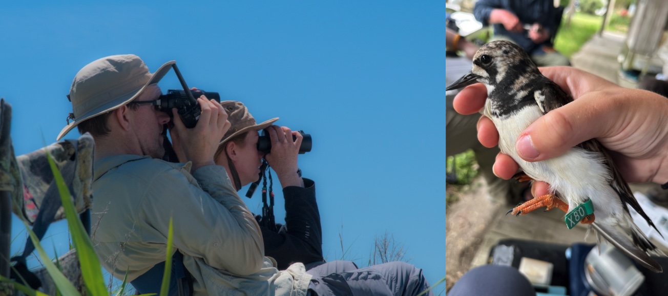
Delaware has a wealth of monitoring programs that provide important information about wildlife species and their habitats. The table below detailing wildlife species and habitat monitoring programs in Delaware was originally developed for the first and second editions of the DEWAP. They have been updated and enhanced based on information provided during the process of revising the DEWAP, and will continue to be updated as monitoring programs change through the life of the DEWAP. The tables list individual monitoring programs, the associated organization(s) with each program, and the type and level of monitoring. Data from these programs and process-related information from individual implementation projects (e.g., number of meetings held, number of reports produced, number of people contacted through outreach efforts, number of plans developed, etc.) will be reported to the USFWS and tracked using the Wildlife TRACS database.
A key part of adaptive management is the determination of specific management objectives for SGCN, key habitats, and abatement of threats from conservation issues. These would take the form of population levels for SGCN, areal extent and dispersion for key habitats, and maximum limits for impacts from “direct threat” conservation issues. Such objectives are often difficult to determine given the complexity of most natural systems, and they are beyond the scope of this plan. However, population objectives are available for some species in regional and national conservation initiatives (e.g., Partners in Flight and endangered species Recovery Plans), and there is extensive literature on population viability analysis that can be applied to other species. Habitat objectives are less well developed, although there is a growing body of knowledge about patch size and isolation, connectivity, edge effects and similar factors that influence habitat viability. Some thresholds for impacts are well established, while others are poorly understood and require additional research.
Delaware has numerous monitoring programs already in place that monitor individual wildlife species as well as important species guilds such as shorebirds, raptors, waterfowl and diadromous fish. These existing programs will continue to be the primary method for monitoring and tracking species identified as SGCN in the current revision of the DEWAP. Data from these programs are collected and reported to the relevant partners and wildlife managers at the state and federal level, in order to provide information that can be used for adaptively managing these important wildlife populations.
Because species monitoring programs listed in this table have been designed for different purposes and may track different attributes of individual species or groups of species, the existing species monitoring programs in Delaware may not all be reporting similar types of data for all species that are being tracked in the state.
Delaware also has numerous monitoring programs already in place that monitor various attributes of wildlife habitats, from the site-specific local level all the way up to statewide and regional levels. These existing programs will be the primary means for monitoring the condition, extent, and status of wildlife habitats identified in this SWAP. Data from these programs are collected and reported to the relevant wildlife managers at the state and federal level, in order to provide information that can be used for adaptively managing these important wildlife habitats.
Because the habitat monitoring programs have been designed for different purposes and may track different attributes of individual sites or ecological communities, the existing habitat monitoring programs in Delaware may not all be reporting similar types of data for all habitats that are being tracked in the state.
Although limited resources prevent the monitoring of a significant number of the aspects of the natural or human environment relevant to fish and wildlife conservation efforts, it is possible to identify high-priority target areas where additional data would be helpful for developing management prescriptions for fish and wildlife species and their habitats. SGCN and Conservation Actions both identify high priority data gaps identified by taxa experts, planners, and stakeholders through the DEWAP review process. Examples include taxa such as invertebrates, small mammals and fresh water nongame fish where baseline data do not exist to form the basis of a monitoring protocol. DNREC plans to work with partners to develop monitoring programs to address these gaps including species, taxa, habitat and community-level monitoring. This will be an important step towards providing wildlife managers in Delaware with the information they need.
Plans and programs listed below show existing monitoring efforts and tools currently used by DNREC DFW and its partners to assess SGCN, key habitats, and related issues. Creating new programs to address the needs identified in Conservation Actions will require extensive coordination. DNREC will play a lead role, involving key partners and stakeholders in identifying new or expanding current monitoring programs that can be implemented by federal, state, and local governments, non-governmental organizations, universities, and other partners.
The timeliest measures of success are those that directly monitor the rate of plan implementation, but the degree to which partners integrate SGCN, key habitats and conservation actions into their plans and programs is just as important as a SWAP performance measure.
The purpose of tracking effectiveness measures is to obtain the information needed to adaptively manage fish and wildlife species and habitats in the state. Delaware is committed to an adaptive management approach to fish and wildlife conservation. The effectiveness of conservation actions described in this plan will be measured using a set of standardized effectiveness measures that have been developed by AFWA and described in their 2011 Measuring the Effectiveness of State Wildlife Grants Final Report (AFWA 2011). Actual values for these measures will be entered into the USFWS Wildlife TRACS database, and comparisons of the values of these measures over time will be used to establish the degree of effectiveness of individual projects as well as broader conservation programs.
Delaware is committed to an adaptive management approach to fish and wildlife conservation and will track effectiveness measures in order to obtain the information necessary to do so. Adaptive management of SGCN, key habitats, and conservation issues will be facilitated primarily through regular progress reviews by the Core Team. This process can be visualized as follows:
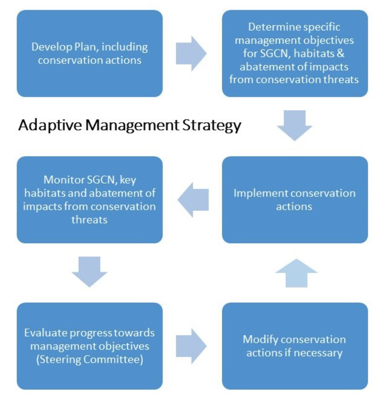
Implementation performance indicators for measuring success are shown below. Once a decision support application is in place, information on all of these indicators may be collected initially. However, it is anticipated that, with experience, a subset will be selected that best measures the effectiveness of the plan as a whole. Implementation performance indicators are measures of overall plan success, and validation indicators are applied across all conservation actions. On the other hand, effectiveness indicators are specific to individual actions, and will be developed as actions are employed. Also, any indicator may require modification over time, or additional indicators may need development if entirely new conservation actions arise as part of an adaptive management approach.
| Guiding Principle for Conservation Actions | Implementation Performance Indicators |
|---|---|
| Management on Conservation Lands – Direct management in state wildlife areas – and state parks and state forests in keeping with their primary missions – towards key habitats and SGCN in the Green Infrastructure (GI) Natural Resources Focus Area, in order to protect and restore habitats and species, and to abate the impacts of conservation issues. Encourage Federal and NGO land managers to focus on this same objective. | # of acres/miles of viable key habitats protected or restored in managed areas in GI Natural Resources Focus Area # of managed area plans incorporating conservation actions in GI Natural Resources Focus Area Response of targeted SGCN or Key Habitat to management actions |
| Management on Private Lands – Direct private lands management towards buffering and connecting conservation lands in the Green Infrastructure Natural Resources Focus Area, and towards protecting outlying small patch habitats and SGCN. | # of landowners enrolled in conservation programs in GI Natural Resources Focus Area # of acres/miles of key habitats protected or restored in GI Natural Resources Focus Area # of dollars appropriated or spent for incentive programs in GI Natural Resources Focus Area # of turnkey services developed Response of targeted SGCN or Key Habitat to management actions |
| Measures of Success, Monitoring, Research and Adaptive Management – Establish performance indicators to measure the success of conservation actions and plan implementation. Monitor species, habitats and impacts of conservation issues, and conduct applied research, so as to facilitate adaptive management. | % of conservation actions initiated or completed by DFW # of standardized monitoring protocols developed # of specific performance indicators developed # of management plans incorporating adaptive management framework Scorecard developed or updated |
| Data Collection and Information Management – Collect, manage and analyze data to support wildlife diversity conservation efforts with sound science. | # of spatial database applications for decision support installed or updated # of users of decision support applications # of agencies and organizations incorporating SGCN and key habitat data into decision making |
| Division Operations – Reorganize, revise and/or enhance DFW administrative structure, staffing, budgeting, procedures and practices as necessary to facilitate implementation of the DEWAP. | % of known species with current Natural Heritage ranks % of SGCN and key habitats with current distribution and status/condition information # of standardized or compatible ecological classification systems developed # of risk assessments initiated or completed for “direct threat” conservation issues # of management plans initiated or completed for SGCN, key habitat and “direct threat” conservation issues # of research projects initiated or completed # of hours of DFW staff time devoted to SGCN and key habitat conservation # of dollars of State and Federal funding appropriated or spent for SGCN and key habitat conservation |
| Partnership Development – Strengthen partnerships with other conservation agencies and organizations to link landscapes, tie together complementary approaches, and leverage investments of time, staff and money. | # of hours of partner staff time devoted to SGCN and key habitat conservation # of dollars of partner funding appropriated or spent for SGCN and key habitat conservation # of conservation actions initiated or completed by partners |
| Education, Outreach and Enforcement – Increase public knowledge of wildlife conservation issues to develop an understanding of habitats, SGCN, and conservation issues and actions; foster a sense of responsibility for personal choices; actively engage citizens in conserving natural resources; and otherwise cultivate support for wildlife diversity conservation. Enforce regulations to promote responsible behavior in interactions with wildlife. | # of State staff trained on key habitat ecology, SGCN biology, and conservation issues and actions # of “profile brochures,” “citizens guides” and wildlife viewing guides initiated or completed # of Adopt-a-Wetland and Backyard Habitat participants # of Certified Citizen Naturalists # of schoolyard habitats initiated or completed # of enforcement actions pertaining to SGCN and key habitats # of hours of DFW staff time devoted to enforcement of regulations protecting SGCN and key habitats |
| Conservation of Species vs. Habitats – Target the preservation or restoration of SGCN, but emphasize the management of ecological structure and function of key habitats over management of individual specie | # of viable SGCN occurrences, or SGCN population levels # of species added to or removed from SGCN list or State endangered list, or with changed Heritage rank # of acres/miles of viable key habitats Response of targeted SGCN or Key Habitat to management actions |
While the evaluation of conservation actions will continue annually through annual project reporting in TRACS and Federal Aid reports, and as new information becomes available, the DEWAP document will be amended as needed and revised every ten years. Annual federal assistance reports will provide new information from SWG and other Federal Aid projects that will be entered into TRACS, the DEWAP database, and GIS spatial data coverage in order to capture and update the annual accomplishments, changes in SGCN and key habitat status, and the effectiveness of actions. DNREC DFW staff and technical committees will assess the status of SGCN and key habitats as new data are entered annually or at the end of these projects. This 10-year revision schedule will be long enough to be practical in terms of administrative loads but short enough to be responsive to changing conditions, monitoring and research results, and adaptive management revision.
This appendix lists the key, relevant monitoring plans in Delaware which monitor key species, habitat or conservation issues that are a part of Delaware’s broad monitoring framework. This list represents many partner programs and an important implementation and coordination part of this DEWAP effort to adaptively manage, incorporate, and communicate goals and data as each plan is revised and updated. Because monitoring will occur at the state, local, regional, national and international levels, it will require the establishment of this broad framework for monitoring at all of these levels. This will also allow partners to incorporate the SWG targets into their plans. This directly addresses Elements 5, 6 and 7.
| Existing/Planned Monitoring Programs for Species, Habitats and Conservation Issues | |||||
| Species/Habitat/Issue | SGCN/KWH* | Description | Location | Frequency | Responsible Party** |
| Mollusks | |||||
| Eastern Oyster | Y | Dredging to determine status and trends of spat, juveniles and adults. | State-owned oyster grounds in Delaware Bay | Annual | DNREC Fisheries |
| Freshwater mussels | P | Hand-picking of random plots to determine status and trends. | Freshwater streams statewide | Every 3-5 years (planned) | DNREC Wildlife |
| Freshwater mussels | P | Presence-absence and in-situ water quality monitoring | Freshwater streams statewide | Ondoing | DNREC WAMS |
| Arachnids | |||||
| Horseshoe Crab | Y | Tagging; nocturnal counts of spawning individuals; fishery-independent surveys of relative abundance | Delaware Bay & selected beaches | Annual | CMP, DNS, DNREC Fisheries |
| Horseshoe Crab | Y | Spawning surveys. | Delaware Bay & selected beaches | Annual | DNREC Fisheries, DNERR, CMP |
| Horseshoe Crab | Y | Spawning density. | Inland bays | Annual | CIB |
| Insects | |||||
| Frosted Elfin | Y | Habitat quality and persistence for known populations. Also surveys of suitable but unoccupied habitat. | Selected locations in Sussex County | Annual | DNREC Wildlife |
| Hessel’s Hairstreak | Y | Habitat quality and persistence for known population. Also surveys of suitable but unoccupied habitat. | Single location in Sussex County | Bi-annual | DNREC Wildlife |
| Rare Skipper | Y | Habitat quality and persistence for known population. Also surveys of suitable but unoccupied habitat. | Single location in Kent County | Annual | DNREC Wildlife |
| Rare Skipper | Y | Habitat quality and presence | Single location in New Castle County | Periodic | DWL |
| Butterflies | Y | Surveys for rare and declining species | Statewide | Annual | DNREC Wildlife |
| Moths | Y | Surveys for rare and declining species | Statewide | Annual | DNREC Wildlife |
| Tiger Beetles | Y | Surveys for rare and declining species | Statewide | Annual | DNREC Wildlife |
| Odonates | Y | Surveys for rare and declining species | Statewide | Annual | DNREC Wildlife |
| Hoverflies | Y | Surveys for rare and declining species | Statewide | Annual | DNREC Wildlife |
| Fireflies | Y | Monitoring and surveys of rare and declining species | Annual | DNREC Wildlife | |
| Bethany Beach Firely | Y | Habitat quality, monitoring | Interdunal swales | Annual | DNREC Wildlife |
| Farming for Native Bees | Surveying native bees associated with cucurbit/mixed organic crops in Delaware. | Statewide. | 2007-10 | PI | |
| Fish | |||||
| Adult, sub-adult and juvenile estuarine fish & shellfish | P | 30 foot trawl in nine fixed plots (adults and sub-adults) and 16 foot trawl in 51 fixed plots (juveniles) to determine status and trends. | Delaware Bay (all) & Inland Bays (juveniles only) | Monthly, Mar-Dec (adults & sub-adults), Apr-Oct (juveniles) | DNREC Fisheries |
| Freshwater fish | P | Electrofishing of fixed plots to determine status and trends. Also, collection of data on water quality, physical stream characteristics, riparian vegetation and landscape context. | Freshwater streams statewide | Every 3-5 years (planned) | DNREC Fisheries |
| Striped Bass | N | Tagging, electrofishing, trawling, and sampling of recreational and commercial landings to determine age, size, sex composition and food habits. | Delaware Bay | Various: mostly weekly in spring and fall | DNREC Fisheries |
| American Shad | N | Tagging, electrofishing, seining and sampling of commercial landings to determine abundance of juveniles and adults and age, size and sex composition of adults. | Nanticoke River and Delaware River & Bay | Various: weekly or monthly, spring or summer and fall | DNREC Fisheries |
| Hickory Shad | Y | Tagging, electrofishing and seining to determine abundance of juveniles and adults. | Nanticoke River | Weekly, summer and fall | DNREC Fisheries |
| Blueback Herring & Alewife | Y | Seining to establish index of year class strength. | Nanticoke River | Weekly, summer and fall | DNREC Fisheries |
| American Eel | Y | Fyke nets and sampling of commercial landings to determine abundance of elvers and age and size of adults. | Delaware River & Bay; Inland Bays | Various: weekly or monthly, spring or summer | DNREC Fisheries |
| Freshwater sportfish | N | Electrofishing to determine abundance, size structure, community indices, and growth rates. | Selected lakes/ponds statewide | 5 years | DNREC Fisheries |
| Smallmouth Bass | N | Electrofishing to determine abundance, growth rate and size structure. | Brandywine River | Monthly, summer and fall | DNREC Fisheries |
| Largemouth Bass | N | Tagging and electrofishing to determine abundance, size and age structure. | Selected tidal freshwater streams | Annual or semi-annual, summer and fall | DNREC Fisheries |
| Atlantic Menhaden | N | Trawling to determine abundance and size structure; commercial subsampling for size and age | Inland Bays | Weekly, June-Sept | DNREC Fisheries |
| Atlantic Sturgeon | Y | Gill netting and tagging to determine abundance, size distribution and stock ID of juveniles. | Delaware River, Nanticoke River | August-December | DNREC Fisheries |
| Fish Monitoring Study | P | Seine net sampling to determine the numbers of fish by species. | Inland bays and tributaries | Twice monthly | CIB |
| Nekton Survey | P | Nekton trawls | Blackbird Creek | Annual (April-October) | DNERR |
| Amphibians | |||||
| Eastern Tiger Salamander | Y | Mark-recapture surveys for long-term population monitoring. Egg mass counts. Translocation of egg masses to new habitats. Habitat quality monitoring. | New Castle County, Sussex County | Annual | DNREC Wildlife |
| Barking Treefrog | Y | Mark-recapture surveys for long-term population monitoring. | New Castle County | Annual | DNREC Wildlife |
| Spotted Salamander | Y | Breeding pond presence/absence surveys at sites of unknown occupancy. Translocation of egg masses to new habitats. | New Castle County | Annual | DNREC Wildlife, DWL |
| Amphibians | Surveys for rare and declining species | Statewide | Annual | DNREC Wildlife | |
| Reptiles | |||||
| Bog Turtle | Y | Habitat assessments, radio telemetry, trapping surveys, head-starting hatchlings. | New Castle County | Annual | DNREC Wildlife |
| Spotted Turtle | Y | Mark-recapture and rapid assessment surveys. | Statewide | Annual | DNREC Wildlife, DWL |
| Eastern Box Turtle | Y | Mark-recapture and rapid assessment surveys. | Statewide | Annual | DNREC Wildlife, DWL |
| Striped Mud Turtle | Y | Mark-recapture and rapid assessment surveys. | Kent and Sussex Counties | Annual | DNREC Wildlife |
| Reptiles | Surveys for rare and declining species | Statewide | Annual | DNREC Wildlife | |
| Wood Turtle | Y | Radio telemetry. | New Castle County | Annual | DNREC Wildlife |
| Diamondback Terrapin | Y | Volunteer program to assist nesting terrapins across road and trapped in rocks. | Port Mahon Rd., Little Creek, Kent County | Annual, May 25-July 20 | DNREC Wildlife |
| Sea Turtles | Y | Data collection from stranding networks and national databases | Statewide | Annual | DNREC Wildlife |
| Birds | |||||
| Breeding birds | P | Breeding Bird Survey. Counts of ¼ mile radius around fixed points on 8 fixed routes to determine status and trends. | Statewide | Annual | DOS |
| Breeding, non-breeding and migratory birds | P | Mist netting, point counts, and Autonomous Recording Unit (ARU) monitoring of select state wildlife areas to target SGCN. | Selected conservation lands statewide | Annual | DNREC Wildlife |
| Winter birds | P | Christmas Bird Count. Counts along fixed routes within 15 mile radius around 7 fixed points to determine status and trends. | Statewide | Annual | DOS |
| Veery | Y | Banding and observation of nests to determine productivity. | Single location in New Castle County | Annual | DSU |
| Purple Martin | N | Capture and banding juveniles to monitor natal dispersal. Surveying colony locations and occupancy. | Selected colonies for banding, New Castle County for colony survey | Annual | UD, DNS |
| Bald Eagle | N | Aerial and ground surveys of known nest sites. Also aerial and ground surveys of suitable but unoccupied habitat. | Statewide | Every 3–5 years | DNREC Wildlife |
| Forest-dependent songbirds | P | Counts of 50m radius around fixed points to determine status and trends. | Selected conservation lands statewide | Annual or bi-annual | DNREC Wildlife |
| Wood Thrush | Y | Banding and observation of nests to determine productivity for isolated population. | Single location in New Castle County | Annual | DNS |
| Bay Waterfowl, Freshwater Waterfowl | P | Aerial surveys of fixed transects to determine abundance. Aerial and ground surveys of random plots to determine nesting success. | Statewide | Annual, Oct-Jan (transects) or Apr-May (plots) | DNREC Wildlife |
| Bay Waterfowl, Freshwater Waterfowl | P | Banding and marking programs to calculate harvest rates, migration corridors, and other biological information for various species in this group. | Statewide | Annual | DNREC Wildlife |
| Tundra Swan | Y | January aerial survey to determine abundance. Winter ground survey to determine productivity (juveniles per adult). Capture and marking with GPS collars to identify habitat use within DE. | Statewide | Annual, December – January | DNREC Wildlife |
| Atlantic Brant | N | January aerial survey to determine abundance. Winter ground survey to determine productivity (juveniles per adult). | Coastal areas in Sussex County | Annual, December – January | DNREC Wildlife |
| American Black Duck | Y | Capture, banding, and marking with GPS transmitters as part of Atlantic Flyway collaborative project. | Statewide | Annual, January – March | DNREC Wildlife |
| Northern Bobwhite | Y | Capture and marking with GPS and radio transmitters to assess habitat use, survival, and dispersal | Cedar Swamp WMA | Annual, Spring and Fall | DNREC Wildlife, DWL, UD |
| Northern Bobwhite and co-occuring early successional bird species | Y | Call surveys on fixed routes to determine abundance. | Selected State Wildlife Areas and DWL properties | Annual | DNREC Wildlife, DWL |
| Northern Bobwhite | Y | Population monitoring in response to habitat implementation | Select private lands statewide | Annual | TT, QF |
| Mourning Dove | N | Capture and marking with bands | Statewide | Annual, July and August | DNREC Wildlife |
| American Woodcock | Y | Call surveys on fixed routes to determine abundance. | New Castle and Sussex Counties | Annual | DNREC Wildlife |
| Sandhill Crane | Y | USFWS Fall Survey of the Eastern Population of Greater Sandhill Cranes. Used to determine abundance. | New Castle County | Annual, October and November | DWL, DNREC Wildlife |
| Marsh-nesting songbirds and rails | P | Banding and observation of nests to determine distribution and abundance. | Selected conservation lands statewide | Annual | DNREC Wildlife, UD |
| Colonial waterbirds | P | Boat surveys of bird breeding colonies including nest monitoring, for gulls, terns, long-legged waders, and others. | Inland Bays, Delaware River | Annual, April – August | DNREC Wildlife |
| Migratory shorebirds | P | Delaware Shorebird Project. Banding, aerial surveys and ground surveys to determine status, trends and health. | Selected coastal areas | Annual, spring & fall (surveys only) | DNREC Wildlife |
| Long-legged waders | P | Ground survey of evening flights and ground and aerial surveys of nests to determine status and trends. | Pea Patch Island Heronry | Monthly, Feb-Aug (evening flights) or annual (nest surveys) | DNREC Parks |
| Migratory raptors | P | Hawkwatch. Counts of passing birds to determine status and trends. | Ashland, Cape Henlopen and White Clay Creek State Parks | Annual, fall | DNREC Wildlife, DOS, DNS |
| Beach-nesting birds | Y | Ground surveys of suitable habitat. Observation of nests to determine productivity | Selected Delaware Bay beaches | Daily, Mar-Sept | DNREC Wildlife, USFWS |
| Piping plover | Y | Banding adults and chicks to evaluate habitat use and dispersal | Cape Henlopen State Park and Prime Hook National Wildlife Refuge | Annual, March-July | DNREC Wildlife, USFWS |
| American Oystercatcher | Y | Ground surveys of suitable habitat. Observation of nests and banding of nestlings to determine migration, dispersal and productivity. | Selected Delaware Bay and Inland Bay Beaches | Annual | DNREC Wildlife |
| Osprey | Y | Aerial and ground observation and of nests and banding of nestlings to determine status, trends and productivity. | Statewide | 3 years | CIB |
| Peregrine Falcon | Y | Observation of nests and banding of nestlings to determine productivity, fledge watch in Wilmington | New Castle County | Annual | DNREC Wildlife |
| American Kestrel | Y | Nest monitoring, banding and Motus transmitters at nest boxes | Statewide (state and private lands) | Annual | DNREC Wildlife |
| Barn Owl | Y | Banding at nest boxes. | State wildlife areas, national wildlife refuge, select DWL properties | Annual, Biannual | DNREC Wildlife |
| Salt Marsh Bird Community | Y | Abundance, fecundity and survival. | Selected conservation lands statewide | Annual | DNREC Wildlife, UD, USFWS |
| Marsh-nesting songbirds and rails | P | Point count and callback survey of tidal marsh passerines and secretive marshbirds, per the Saltmarsh Habitat and Avian Research Program (SHARP) protocol | Statewide | Annual | USFWS, DNREC Wildlife, UD, DNERR |
| Migrating and wintering waterbirds (waterfowl, shorebirds, and wading birds) | P | Area counts of all waterbirds during fall, winter, and spring, including assessment of habitat conditions, per the Integrated Waterbird Management and Monitoring (IWMM) Program | Coastal DE NWR Complex (Prime Hook & Bombay Hook NWRs) | Annual | USFWS, DNREC Wildlife |
| Mammals | |||||
| Delmarva Fox Squirrel | Y | Trapping, tagging, radio telemetry, and photomonitoring to determine status and trends and monitor success of translocation projects | Statewide | Annually | DNREC Wildlife |
| Bat surveys | Y | Acoustic monitoring, rare species trapping, tagging and radio-telemetry (planned), white-nose syndrome monitoring and maternity colony monitoring | Statewide | Annual | DNREC Wildlife |
| American Mink | Y | Visual occupancy survey, raft-camera photomonitoring | Statewide | Bienniall (visual occupancy), Annual (camera – planned) | DNREC Wildlife |
| Long-tailed Weasel | Y | Photomonitoring | Statewide, Wildlife Areas | Ongoing | DNREC Wildlife |
| Gray Fox | Y | Photomonitoring (planned) | Statewide | Planned | DNREC Wildlife |
| Seals | Y | Monitoring populations of seals in the Delaware Bay | Delaware Bay (inner/outer wall) | Unknown | MERR/U.S. Coast Guard |
| Marine Mammals | Y | Data collection from stranding networks and national databases | Statewide | Annual | DNREC Wildlife |
| Habitats | |||||
| Estuarine wetlands | P | Water chemistry to determine habitat condition including temperature, specific conductivity, salinity, dissolved oxygen concentration, dissolved oxygen percent saturation, pH, turbidity, and depth. | Inland Bays, Broadkill River, Blackbird Creek and St. Jones River | Annual | CIB and DNERR |
| Delmarva Bays | Y | Monitor restored and historic Delmarva Bays in DWL’s Taylors Bridge Complex for water quality and key species and vegetation presence. | New Castle County | Annual (quarterly) | DWL |
| Wetlands | P | DECAP – The Delaware Comprehensive Assessment Procedure is a comprehensive assessment method for collecting data used to determine the condition of a wetland site relative to reference condition. DECAP can be used to assess flat, riverine and depressional nontidal wetland subclasses in the Coastal Plain of Delaware and Maryland. DERAP – The Delaware Rapid Assessment Procedure is a rapid field method to determine the general condition of a wetland sites | Statewide Flat, riverine, and depressional wetlands in Delaware | Ongoing | DNREC Watershed Assessment Section and Partners |
| Estuarine Emergent Tidal Wetlands | P | MidTRAM – The MidAtlantic Tidal Rapid Assessment Method is a rapid protocol for assessing the condition of estuarine emergent tidal wetlands.The MidTRAM is validated with intensive biological data based on the bird community and biomass levels | Estuarine emergent tidal wetlands in Delaware, Maryland, and Virginia | Ongoing | DNREC Watershed Assessment Section and Partners |
| Non-tidal streams | P | Physical stream characteristics, macroinvertebrates and periphyton using EPA Rapid Bioassessment Protocols in 50 fixed transects to determine stream condition. | Non-tidal streams statewide | Annual (physical, inverts) or bi-annual (periphyton) | ELS |
| Non-tidal streams | P | Habitat assessment, water quality data, and macroinvertebrate identification for Index of Biotic Integrity (IBI) grading of stream health | Non-tidal streams statewide | Ongoing | DNREC WAMS |
| Forests | P | Forest Health Monitoring. Forest type, stand age, regeneration and disturbance; tree species, height and diameter; shrub and herbaceous layers composition; etc. at fixed plots to determine forest condition. | Statewide | Annual | FSV |
| Emergent saltmarsh vegetation | P | Monitoring of emergent saltmarsh vegetation at transects | St. Jones and Blackbird Creek | Biannual | DNERR |
| Refuge Shoreline | P | Refuge Shoreline Position and Topography (planned) monitoring per National Park Service protocols | Prime Hook NWR | Spring and Fall | USFWS |
| Benthic | P | Delaware Estuary Benthic Inventory. Sediment, water quality, fauna, metals, and hard bottom data. | Delaware Basin | 2008-09 | PDE |
| Mosquito Sampling Programs | N | Techniques used to measure mosquito abundance and the presence of mosquito transmitted diseases | Statewide | Ongoing | DNREC Mosquito Control Section |
| Conservation Issues | |||||
| Vehicles from transportation operations | Y | Roadside/roadkill survey of Diamondback Terrapin to determine mortality rate and effectiveness of fencing. | Rt. 1, Delaware Seashore State Park | Daily, June-July | CIB |
| Habitat degradation by invasive plants | Y | Qualitative ground surveys to determine presence/absence of invasive plants. | Selected State Parks | Annual | DNREC Parks |
| Chronic water pollution from residential and commercial development practices, agricultural and forestry operations, industrial operations and transportation operations | N | Water chemistry, organics, biological oxygen demand, nutrients, metals and bacteria at 250+ fixed stations to determine water quality of streams and ponds. | Statewide | Quarterly | WAS |
| Chronic water pollution from residential and commercial development practices, agricultural and forestry operations, industrial operations and transportation operations | N | Water chemistry, organics, biological oxygen demand, pollutants, etc. of point discharges to enforce permit compliance. | Statewide | Various: monthly to bi-annual | SWDS |
| Chronic water pollution from residential and commercial development practices, agricultural and forestry operations, industrial operations and transportation operations | N | Public water supply monitoring of surface water and groundwater | Statewide | Various | WSS |
| Chronic water pollution from agricultural operations | N | Pesticides using monitoring wells to determine groundwater quality. | Statewide | Annual | PMS |
| Groundwater withdrawals for water use | N | Salinity levels using monitoring wells to determine saltwater intrusion into aquifers. | New Castle and Sussex Counties | Annual | WSS & DGS |
| Groundwater withdrawals for water use | N | Groundwater levels using monitoring wells to determine aquifer status. | Statewide | Annual | DGS |
| Surface water withdrawals for water use | N | Stream flows at 20+ fixed gaging stations to determine hydrology. | Statewide | Continuous | USGS |
| Air pollution from industrial operations | N | NOx, SOx, particulates, ozone, etc. at 9 fixed stations to determine air quality. | Statewide | Continuous | AQMS |
| Air pollution from industrial operations | N | Pollutants at 1000+ sites to enforce permit compliance. | Statewide | Various | AQMS |
*SGCN = Species of Greatest Conservation Need; KWH = Key Wildlife Habitat; Y = Yes, N = No, P = In Part
**Source abbreviations:
Related Topics: action plan, conservation, draft, fish and wildlife, habitat, plan, species, wildlife
Delaware's Governor
State Agencies
Elected Officials
General Assembly
Delaware Courts
State Employees
Cities & Towns
Delaware State Code
State Regulations
Business First Steps
Phone Directory
Locations Directory
Public Meetings
Voting & Elections
Transparency
Health Insurance
Tax Center
Personal Income Tax
Privacy Policy
Weather & Travel
Contact Us
Corporations
Franchise Tax
Gross Receipts Tax
Withholding Tax
Delaware Topics
Help Center
Mobile Apps
E-mail / Text Alerts
Social Media

Built by the Government Information Center
©MMXXVI Delaware.gov