

DNREC Menu
The 2025 Wildlife Action Plan generally uses the same wildlife habitat classification scheme as the 2015 Wildlife Action Plan (DNREC DFW 2015). This classification includes all terrestrial and aquatic habitats.
Terrestrial habitats and palustrine and estuarine wetland habitats were aligned as closely as possible with NatureServe Ecological Systems and the Northeast Terrestrial Wildlife Habitat Classification (Gawler 2008). Ecological systems are recurring groups of terrestrial biological communities that are found in similar physical environments and are influenced by similar dynamic ecological processes, such as fire or flooding. They are based on biogeographic region, landscape scale, dominant cover type, and disturbance regime.
The Northeast Terrestrial Habitat Classification System (NETWHCS)(Gawler 2008)is a standardized classification of wildlife habitats based largely upon ecological systems, with the addition of classifications for anthropogenic systems. The NETWHCS aligns with a GIS map of ecological systems based on 70,000 inventory points contributed by the state Natural Heritage programs (NHPs) and the U.S. Department of Agriculture (USDA)-USFS Forest Inventory and Analysis (FIA) program. In addition, the Northeast Habitat Guide: A Companion to the Terrestrial and Aquatic Maps was published by TNC (Anderson et al. 2013b). It includes a profile of each habitat type in the Northeast, as well as distribution maps, state acreage figures, identification of species of conservation concern, and assessment of overall conditions in the region. For Delaware, the Anderson et al. (2013a) profiles were considered when appropriate, although state-based data were often found to be more appropriate at this scale.
Stream and river habitats were aligned with the Northeast Aquatic Habitat Classification System (Olivero and Anderson 2008) and marine and estuarine aquatic habitats were aligned with the Federal Geographic Data Committee (FGDC) Coastal and Marine Ecological Classification Standard (CMECS) and the Atlantic Coastal Fish Habitat Partnership (ACFHP) habitats.
As a thorough assessment of habitats has not completed in Delaware since the 2015 Wildlife Action Plan, we maintained the existing habitat descriptions and extent. However, there remains a need in the next ten years to conduct a thorough assessment of habitat status.
Numerous resources helpful to the assessment of habitat condition and extent in Delaware have been developed. The entire state is covered by a GIS layer of Delaware Vegetation Communities based on the Coxe (2014) community types, allowing assessment of habitat extent by vegetation type. Several broad habitat classes also have relatively recent condition assessment information, including forests (Delaware Forest Service 2020) and wetlands (DNREC 2022).
Through an integrated effort by the Delaware Coastal Programs, the University of Delaware, and Delaware State University, a benthic and sub-bottom imaging project to identify and map the benthic habitat and sub-bottom sediments of Delaware Bay and River was initiated. This effort has resulted in many major milestones, which include: mapping over 350 square miles, identifying the spatial extent and relative density of the oyster and Corbicula beds, and locating key habitats for several species. In addition, the Delaware Estuary Benthic Inventory (DEBI), a cooperative project led by the Partnership for the Delaware Estuary, resulted in a significant body of information on the condition and extent of benthic habitats in the Estuary (Kreeger et al. 2010).
The Northeast Habitat Guides and GIS map products developed by TNC (Anderson et al. 2013a,b) address condition and extent of ecological systems and aquatic habitats in the northeast region.
Perhaps most significantly, a major landscape mapping and conservation prioritization effort, the Delaware Ecological Network (DEN) was developed by The Conservation Fund in 2007 (Weber 2007) and updated in 2013 (Weber 2013).
Several habitat types are further identified by Delaware staff as Habitats of Conservation Concern. Habitats of Conservation Concern were primarily determined by the relative high presence of state rare plant and animal species, and the state and global rarity status of the plant community. The Habitat of Conservation Concern designation can be viewed alongside habitat descriptions and extent in the DEWAP Web Map.
Habitats were mapped using a variety of available sources, primarily the vegetation community GIS data of Coxe (2014), the Northeast Aquatic Habitat data of Olivero and Anderson (2008) and Anderson et al. (2013b), state-level wetlands data, and land use, land cover (LULC) data, as well as the Northeast Terrestrial Habitat Map for some habitats that were not well-represented by state-level data.
Many habitat types are not well-represented currently by available spatial data, or the spatial data do not closely match habitat types as defined here, and these habitats do not have corresponding mapped habitat data. As habitat mapping is improved over the life of the 2025-2035 Delaware Wildlife Action Plan, the web-map for the DEWAP will be updated to represent more recent habitat distribution information.
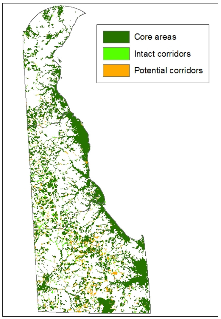
Nearly all of Delaware’s habitats are used to some extent by at least one SGCN. For the DEWAP, terrestrial and wetland habitats can be spatially prioritized using the Delaware Ecological Network (DEN) and a habitat’s status as a Habitat of Conservation Concern. The DEN, based on principles of landscape ecology and conservation biology, provides a consistent framework to help identify and prioritize areas for natural resource protection.
The DEN is composed of the following elements: (1) core areas, which contain relatively intact natural ecosystems, and provide high-quality habitat for native plants and animals; (2) existing corridors, which link core areas together, allowing wildlife movement and seed and pollen transfer between them; and (3) potential corridors (Weber 2007, 2013). The DEN is built using several important layers, notably including the Habitats of Conservation Concern (HCC) layer and a rare species element occurrence data from Delaware’s Biotics database. DEN core areas total 346,195 acres, or 27% of the state (not including offshore water). Existing corridors total 28,664 acres (2.2% of the state), and potential corridors total 43,985 acres (3.4% of the state). When developed, DEN core areas and corridors contained 85% of rare species locations and 99.6% of habitats of conservation concern.
When used in a GIS environment, in conjunction with habitat mapping, the DEN provides a powerful tool to prioritize examples of habitats on the landscape. A habitat type may be mapped, and that map, when overlaid with the DEN layer, will indicate prioritized examples of that habitat type based upon their inclusion in the DEN and their DEN score.
Some habitat types are not well captured by the DEN model. These include early successional habitats, estuarine and marine aquatic habitats, and various microhabitat features described in this chapter. High quality examples of these habitat types should be considered priority habitats in addition to the DEN modeled terrestrial and wetland priority habitats.
Related Topics: action plan, conservation, draft, fish and wildlife, habitat, plan, species, wildlife
Delaware's Governor
State Agencies
Elected Officials
General Assembly
Delaware Courts
State Employees
Cities & Towns
Delaware State Code
State Regulations
Business First Steps
Phone Directory
Locations Directory
Public Meetings
Voting & Elections
Transparency
Health Insurance
Tax Center
Personal Income Tax
Privacy Policy
Weather & Travel
Contact Us
Corporations
Franchise Tax
Gross Receipts Tax
Withholding Tax
Delaware Topics
Help Center
Mobile Apps
E-mail / Text Alerts
Social Media

Built by the Government Information Center
©MMXXVI Delaware.gov