

DNREC Menu
A goal of SWAPs is the development of COAs that map and prioritize opportunities for conservation of key habitats and SGCN. AFWA Best Practices (2012) recommend that WAPs identify and spatially depict priority areas on the landscape that offer the best opportunities and potential for SGCN conservation, designating them as “Conservation Opportunity Areas” (COAs). Collaborative efforts at the regional scale in the Northeast have resulted in the development of regional guidance as well. The completion in 2023 of the Northeast Regional Conservation Synthesis for 2025 State Wildlife Action Plans provides the details and framework to include COAs as a significant conservation action to include in WAPs (Terwilliger Consulting Inc. and NEFWDTC 2023). Identification of COAs at the state level relies directly on the regional effort, with input from the DEWAP Revision Team and DNREC DFW staff. The core team and staff were also informed by other partner efforts that identified areas important to Delaware’s wildlife. These included resources such as the DE Bayshore Initiative, Delaware Ecological Network, Habitats of Conservation Concern, and Audubon’s Important Bird Areas (IBA), among others.
DNREC and its aquatic partners’ programs informed aquatic COA identification. Marine and estuarine COA development considered the National Oceanic and Atmospheric Administration, National Marine Fisheries Service (NOAA NMFS) Essential Fish Habitat and the Atlantic Coast Fish Habitat Partnership efforts. Freshwater COAs were informed by regional and statewide connectivity and water quality efforts and the water quality monitoring programs of DNREC and its partners. A DNREC/EPA partnership developed Watershed Resources Registry (WRR; https://watershedresourcesregistry.org/states/delaware.html) that is used to model and assist in prioritizing freshwater habitats and COAs in Delaware.
Factors in the development of COAs include the availability of quality geospatial data for the habitats and species of interest, information from literature, and expert opinion available for habitats and species with insufficient geospatial data. DNREC and its partners fortunately have relatively good spatial data layers that may be used to develop COAs. Recent mapping of vegetative communities and wetland assessments provide updated, quality fine-scale data.
The Nature Conservancy has partnered with multiple land protection and conservation organizations in Delaware to produce the Delaware Conservation Blueprint (https://www.nature.org/content/dam/tnc/nature/en/documents/DE_Conservation_Blueprint_2024.pdf). The blueprint establishes Conservation Opportunity Areas across Delaware with a pointed focus to address sea level rise risks and target conservation in rare habitats and large habitat blocks.
Rather than create an additional map layer for COAs, DNREC is providing integrated online access to the existing and overlapping Geographic Focus Areas and Planning Models such as the Delaware Bayshore and the Delaware Ecological Network in order for partners and the public to evaluate Conservation Opportunity Areas at various scales and build upon the extensive work already completed by state agencies and partner organizations. This supports these existing programs and ensures more consistent use and application of these synergistic programs by DNREC and its partners.
Delaware’s approach to Conservation Opportunity Areas (COAs) is to overlay existing tools and priority areas to help land managers and conservation groups prioritize their work in the state, as was done with The Nature Conservancy’s Delaware Conservation Blueprint. This approach includes both large-scale, discrete geographic focus areas generated by state and partner programs, as well as site-scale planning models such as the Delaware Ecological Network (DEN) and the Delaware Water Resources Registry. The Delaware WRR includes models to identify both conservation and restoration opportunities for freshwater aquatic habitats using a set of metrics derived from geospatial data.
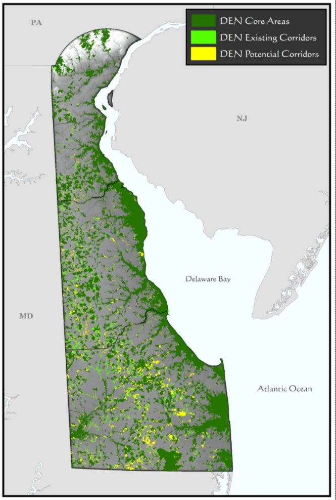
The existing DEN also provides an important planning/modeling tool that can be used in combination with the landscape-scale focus areas to assist in preservation and restoration project prioritization. DEN core areas and existing corridors represent ranked areas for conservation, while DEN potential corridors provide a blueprint for restoration or conservation in areas that can connect existing cores and corridors. These DEN modeled areas are the foundation of the DEWAP COAs.
The DEN serves as the foundation of the DEWAP Priority Wildlife Habitat and facilitates the development of COAs, Priority Wildlife Habitat includes Core Areas and Existing Corridors. In this section describing DEWAP Conservation Actions and Opportunities, COAs may be developed to add a spatial component to conservation opportunities to facilitate and focus these actions on the ground. The DEWAP COA model, based upon the DEN Priority Habitats, add additional components of Potential Corridors and other important geographic focus areas identified by existing Delaware conservation efforts to take that a step further.
Several partners and programs have already identified landscape-scale focus areas for conservation in Delaware. These focus areas represent largely intact and ecologically significant landscapes that are being incorporated into the DEWAP COA model.
Delaware DNREC’s Delaware Bayshore Initiative has identified focus areas for the Delaware Bayshore region. Watershed-based focus areas have been delineated for the Delaware Inland Bays. The Nature Conservancy and DFW produced a plan with focus areas for the critical Blackbird-Millington Corridor. The Great Cypress Swamp area along Delaware’s southern boundary is anchored by 10,000 acres of protected lands owned by Delaware Wild Lands, Inc. and is the focus of ongoing conservation and restoration work. The Nanticoke River Watershed Restoration Plan is a multi-partner plan that identifies restoration and conservation targets for water quality and wildlife habitat throughout this ecologically important area. Since its official designation as a National Wild and Scenic River in 2000, the National Park Service, the White Clay Creek Steering Committee, and partner organizations have been working together to conserve White Clay Creek and implement the White Clay Creek Watershed Management Plan.
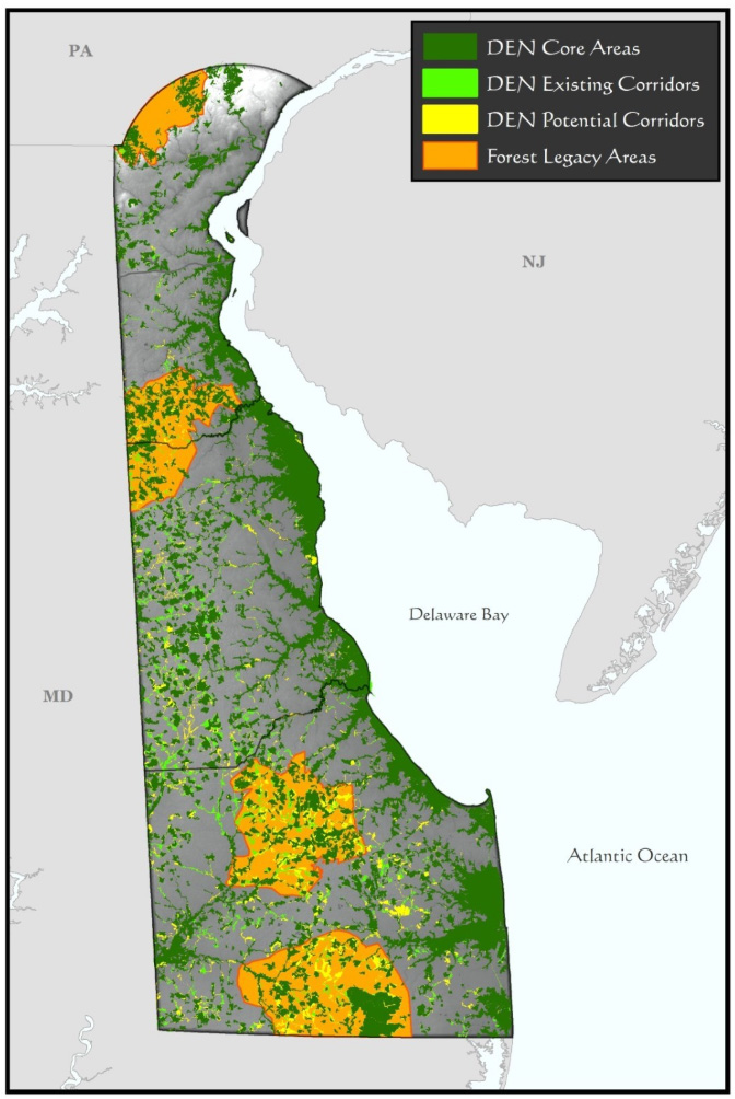
The U.S. Forest Service Forest Legacy Program (FLP) provides funds to states to protect working forestlands that are threatened by development or other land uses, either through outright (fee simple) purchase or conservation easements. Delaware’s four Legacy areas are: White Clay Creek, Blackbird/Blackiston, Redden/Ellendale, and Cypress Swamp. These areas contain the highest concentrations of forests in Delaware, including significant acreage already protected through public and private ownership.
Efforts continue to identify and compile information on important marine and estuarine habitats in Delaware. Examples include such features as shoals, artificial reefs, oyster reefs, and potential spawning areas (e.g. Marcus Hook for Atlantic Sturgeon). DFW continues to identify information and spatial data on estuarine and marine SGCN, and areas considered as important to SGCN. Information from multiple sources, including DNREC’s DFW, NMFS Essential Fish Habitat, the Atlantic Coast Fish Habitat Management Plan, DNREC ‘s Coastal Program, Mid-Atlantic Regional Council on the Ocean (MARCO), and others will continue to be compiled and evaluated by DFW.
The Delaware River Basin Conservation Initiative provides a framework for evaluating and prioritizing a discrete set of freshwater, estuarine, and bay-related ecosystems and habitat-forming species of the Delaware River Basin Conservation Initiative. The goal was to create a biodiversity-driven conservation blueprint for the Basin that would help to ensure a healthy Delaware River and Bay. With funding and guidance from the National Fish and Wildlife Foundation (NFWF), TNC, Partnership for the Delaware Estuary, and Natural Lands Trust examined a suite of ecosystems and habitat-forming species, including floodplains, headwaters, non-tidal wetlands, freshwater tidal marsh, brackish and salt marsh, and oysters and ribbed mussels. For each freshwater and tidal marsh ecosystem, factors related to their condition, including aquatic connectivity, flow regime, landscape condition, size, and resiliency were assessed. The assessment identified conservation priorities for several important ecosystems (see Delaware River Basin Priority Conservation Areas and Recommended Conservation Strategies).
An example of how these focal areas will be used to enhance the DEN model foundation for the DEWAP COA model is illustrated below by adding the Forest Legacy focal areas that are already available. Additional area layers from the focal areas mentioned above can be added to enhance the COAs further when data becomes available. Efforts to improve and refine the COA model will continue over the next decade so that they can better inform local and state planning and provide guidance for partners in their statewide conservation efforts.
Conservation Actions for Delaware’s priority wildlife habitats are presented in the database under their broader habitat types. Within each broad habitat type, priority actions are presented for each wildlife habitat it contains. Many actions are common to multiple habitats, while others are specific to one or a few more specific habitats (which are listed with the actions). Conservation issues and actions (including research/survey/monitoring needs) are identified for each habitat. The Habitat section of the DEWAP describes each key habitat and vegetation community definition, location and condition in more detail. Examples of the DEWAP indicators for habitat actions include measuring the response of the habitats to these actions and are an important component of the DEWAP database.
In addition to the previously listed, broad, overarching actions that apply statewide to SGCN and key habitats, the DEWAP database also lists conservation actions and research, inventory, and monitoring needs developed to address threats to species, multiple species, or taxa, often at the level of ecological group. This list also reflects actions and needs identified in partners’ plans for Delaware’s SGCN groups.
For nearly all SGCN, the majority of actions apply to ecological groups to reduce redundancy within the DEWAP database, but, more importantly, to show the connectivity between species and how an identified action will potentially benefit more than a single species. However, for some species, the DEWAP identifies very specific actions focused on the support and recovery of that specific taxon and that directly relate to the specific threats that the taxon faces, regardless of SGCN Tier. DEWAP database users should note that although many species, including many Tier 1 species, do not have any species-specific actions associated with them, the importance of those actions for their associated ecological groups is not diminished.
The Northeast States are committed to collaborative, proactive, landscape-scale conservation by strategically utilizing resources to implement conservation actions that drive tangible change across priority landscapes in the Northeast. Landscape-scale conservation efforts are characterized by conservation of connected and healthy ecological systems, use of science-based and culturally sensitive conservation planning, collaborative network structure and meaningful multi-sector stakeholder engagement.
One avenue Delaware participates in landscape conservation is via the Northeast Landscape Wildlife Conservation Committee. Established in 2022 and housed within the Northeast Association of Fish and Wildlife Agencies (NEAFWA), the Committee builds on decades of interjurisdictional conservation in the Northeast and provides leadership and direction on large-scale landscape conservation needs and opportunities across the Northeast region. As a landscape-scale conservation partnership, the Committee undertakes work in the context of the long-term goal of sustaining healthy, connected, and resilient cross-border ecosystems that provide essential ecosystem and societal values for current and future generations.
The Committee seeks to fulfill the recommendations found in the 2018 AFWA Resolution entitled “Fish and Wildlife Conservation at Landscape Scales” (AFWA Landscape Resolution), which recognized the need for state, provincial and territorial fish and wildlife agencies, federal agencies, tribes, private landowners, and conservation groups to collaborate at landscape scales.
The Committee has prioritized inter-jurisdictional work in the following 7 landscapes and themes:
In our rapidly changing world, the significance of landscape-scale conservation cannot be overstated. It’s not just about preserving pretty landscapes; it’s about safeguarding the very essence of our existence. Here’s why it matters and how you can help:
Related Topics: action plan, conservation, draft, fish and wildlife, habitat, plan, species, wildlife
Delaware's Governor
State Agencies
Elected Officials
General Assembly
Delaware Courts
State Employees
Cities & Towns
Delaware State Code
State Regulations
Business First Steps
Phone Directory
Locations Directory
Public Meetings
Voting & Elections
Transparency
Health Insurance
Tax Center
Personal Income Tax
Privacy Policy
Weather & Travel
Contact Us
Corporations
Franchise Tax
Gross Receipts Tax
Withholding Tax
Delaware Topics
Help Center
Mobile Apps
E-mail / Text Alerts
Social Media

Built by the Government Information Center
©MMXXVI Delaware.gov